Search
Close this search box.

Another severe weather potential for Wednesday night into Thursday morning

Another round of potentially significant severe weather is expected to impact our local area beginning Wednesday afternoon and into the night. According to the National Weather Service, a powerful storm system will sweep through the area, with the greatest potential for severe weather bring over southeast Mississippi and much of southwest Alabama, where a Moderate […]

Another round of potentially significant severe weather is expected to impact our local area beginning Wednesday afternoon and into the night.

  • According to the National Weather Service, a powerful storm system will sweep through the area, with the greatest potential for severe weather bring over southeast Mississippi and much of southwest Alabama, where a Moderate Risk is now in effect.
  • An Enhanced Risk of severe weather exists across the remainder of the area.

All modes of severe weather are possible including damaging wind gusts, tornadoes and hail. Heavy rains will accompany the storms which may lead to flooding concerns.

The NWS reports that a Wind Advisory is now in effect for the entire area from mid Wednesday morning through the evening hours for wind gusts to 45 mph outside of the storms.

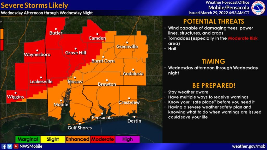
A High Risk of rip currents is in effect from tonight through Friday, and there’s also the potential for coastal flooding especially for areas around Mobile Bay.

“The key takeaway is that confidence is increasing in a substantial severe weather event impacting our area Wednesday into Wednesday night,” said Patrick Maddox, Okaloosa Public Safety Director. “Other threats during that same general time period will be strong, gusty winds outside of thunderstorms, as well as potential coastal hazards along the coast.”

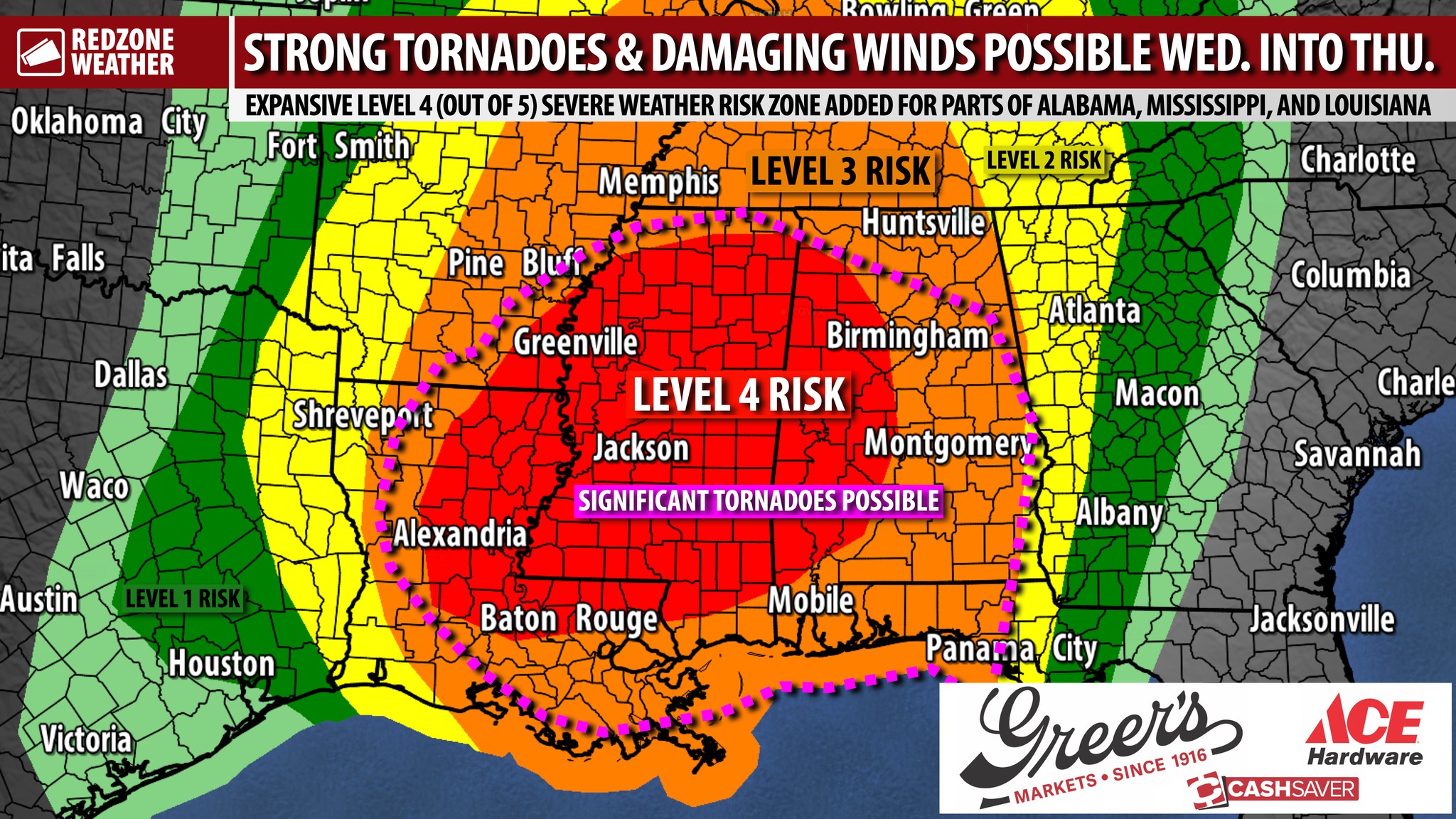
This is the updated convective outlook, valid as of 5am on Tuesday, March 29, 2022.

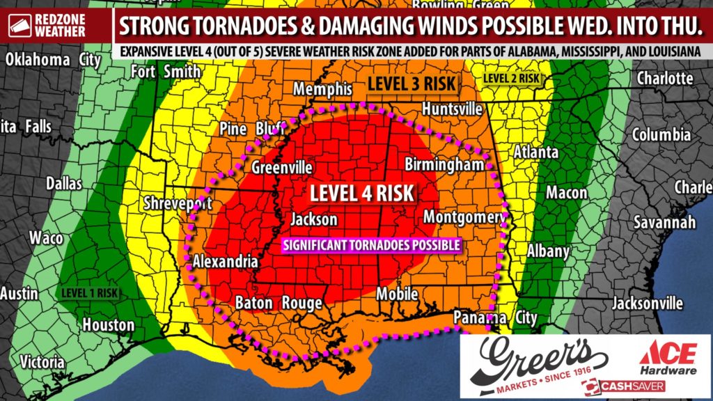
According to Meteorologist Spinks Megginson, regardless of which specific risk zone or color your location is involved in, it should be emphasized we ALL have a potentially significant severe weather risk setting up for Wednesday P.M. into Thursday A.M.

“Unfortunately, it appears this will be another overnight severe weather risk for many locales across the region,” he wrote in his morning briefing. “6PM Wednesday to 6AM Thursday is the 12 hour risk timeframe with 9PM to 3AM being the 6 hour ‘core window‘ for severe storms.”

Local news sent to your inbox 🤝

Thousands of locals read our newsletter every morning! It’s FREE and makes sure that you never miss important local updates.

Join the conversation...

Continue reading 👇

Community Comments

“This article is wrong. There was no privatization of the beaches. Much of the 30A shoreline to the MHWL has been private for decades.”
Respond
“In my town the school day started and ended later. Crime rates went way down! Parents were home when their scholars were home. And scholars aren’t about getting up early!”
Respond
“I wonder just how long the new fencing will last,how long before someone plows into it. I've lived here. For 50 yrs, and can remember the beaches before all the...”
Respond
“The cement wall is ridiculous, just like the wall that use to line the bay side, it will dissappear too, traffic didn't destroy the bay side hurricanes did, to be...”
Respond
“Yea Don Gaetz of all people, he should go!”
Respond
“Why the H... does anyone vote for any politician who is in favor of having the horrible disgusting private beaches? Every resident, every visitor, every tax payer MUST have a...”
Respond
“The air force doesn't own or need the land! It isn't theirs. It was mostly Choctawhatchee National Forest. The air force tried to sell that land in the 2000's but...”
Respond
“Those signs that you recommend have been there for years, just people annoyed them to the point that Eglin has now had to step the game up”
Respond
“Now that Ms. Ketchel has torn down more dunes, plus paved over what was beautiful sand, golf carts can drive from one end to the other. No way to cross...”
Respond

GET OUR FREE LOCAL NEWSLETTER

Get the weekday email that actually makes reading local news enjoyable again.