In 1929, a storm and a well-intentioned trench dug by local residents dramatically altered Destin’s landscape, creating a new East Pass that reshaped the area’s geography and economy. This act of local ingenuity, born out of necessity, has had lasting impacts on the community nearly a century later.
- Vivienne Williams, executive director of the Destin History and Fishing Museum, recounted the events that led to the creation of the current East Pass, which connects Choctawhatchee Bay to the Gulf of Mexico.
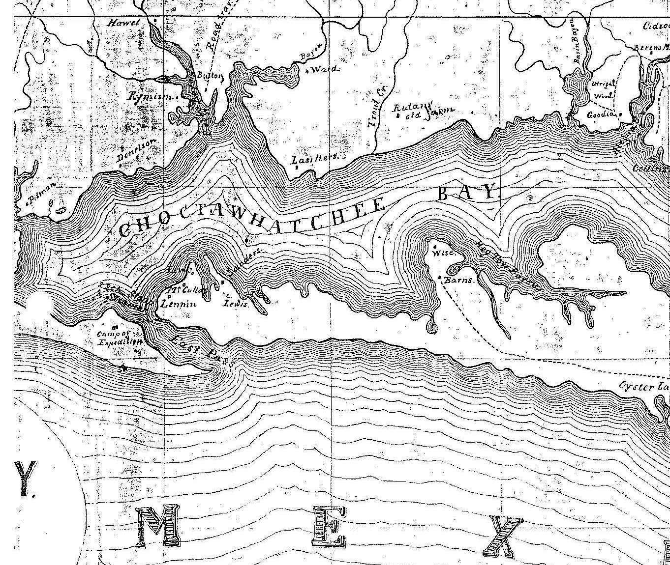
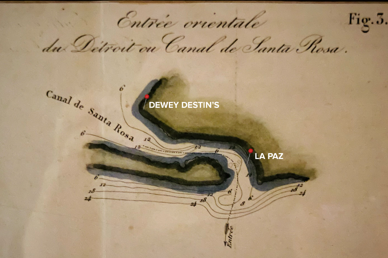
“There was a large storm that passed through Destin that clogged the original East Pass,” Williams said, noting its original location on the east side of Holiday Isle, south of La Paz. The storm raised the bay water eight feet above its normal level, threatening homes and docks along the bay.
The Choctawhatchee Bay, approximately 28 miles long and averaging 5 miles across, was experiencing unprecedented pressure due to the elevated water levels. “That is a lot of pressurized water sitting in one area,” Williams explained.
Many locals in the 1920s had built their homes on the bay side, considering it more forgiving than the Gulf during bad weather. However, this storm proved to be an exception to that rule.
Concerned about the rising water, some locals decided to take action. O.T. Melvin, Dewey Destin Sr., Arn Strickland, and Dolf Weekly, armed with shovels and boat oars, set out to dig a trench from the gulf side to the bay side to relieve the pressure.
- “Knowing what we know about water today, that’s like turning a fire hose onto an anthill,” Williams said. “It’s highly pressurized water and 28 miles of it. That is a heck of a trench.”
The fine, loose sand found in Destin didn’t help matters. As Williams noted, “Our sand here is very fine. It doesn’t hold its shape. So it was going to just streamline through it.”
What started as a six-foot-wide trench quickly expanded beyond anyone’s expectations. “Over the next couple days, it had widened to 500 feet,” Williams explained. “They could hear all the trees crashing, all the sand moving, all the waves going through. It was a very loud ordeal for the next couple days.”
The rapid expansion of the trench created an entirely new body of water, much to the surprise of federal government surveyors who arrived to assess storm damage. “When the surveyors got here, they found an entirely new body of water,” Williams said. “They sat there and they looked at the town of Destin and they went, ‘What happened?‘ And everybody looked at them and went, ‘I have no idea.’”
- The true story of the pass’s creation remained a secret for decades. “Everybody played dumb for about 30 years until they finally fessed up that they were the ones that dug the trench, creating the new body of water,” Williams revealed.
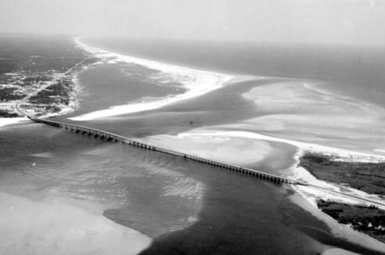
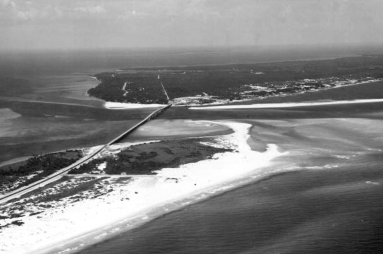
The creation of the new pass had significant and lasting impacts on the area. It closed the old pass where water previously extended from the Bay into the “Old Pass Lagoon,” across what is now Gulf Shore Drive.
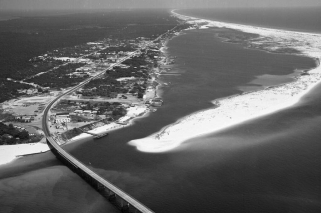
The new pass widened and became the primary channel, creating a sheltered harbor in the process. “It houses the largest licensed fishing fleet in the United States currently to this day,” Williams noted, highlighting the economic importance of this geographical change.
The water flow also eventually affected nearby Crab Island many years later. “The currents changed. Instead of going around Crab Island, they slammed into it,” Williams explained. This erosion, combined with hurricane damage, eventually transformed Crab Island from an actual island into a submerged sandbar.
- To maintain the new pass and prevent it from filling in with shifting sand, jetties were installed to stabilize the opening. “I like to joke that these are the only rocks in Florida,” Williams quipped.
The ecosystem of Choctawhatchee Bay also underwent significant changes following the creation of the new pass. Prior to 1929, the bay was primarily fresh water, fed by springs and rivers. The new, more direct connection to the Gulf increased the bay’s salinity, altering its flora and fauna. Fresh water fish retreated upriver, while salt-tolerant grasses replaced the previous vegetation.
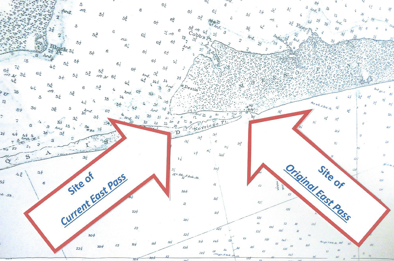
The Destin History and Fishing Museum plays a crucial role in preserving this pivotal piece of local history. “We have replicas on display of the Coast Guard charts actually pre-dating 1926, and then we have a few charts after the storm,” Williams said. These charts show both the new and old passes, illustrating how the coastline has changed over time.
- “At one point in time, you could walk from Destin to Pensacola,” Williams added, highlighting how the creation of the new pass separated what is now Holiday Isle from Santa Rosa Island (what we call Okaloosa Island).
Visitors to the museum are often surprised to learn about the pass’s origins. “They always assume that the pass has been there,” Williams said. The story of East Pass resonates with visitors because, as Williams puts it, “It’s a very human thing to do, right? To do the right thing and then have it get out of hand.”
The Destin History and Fishing Museum continues to update its exhibits to better tell this and other stories of Destin’s rich history. Williams mentioned a recently completed 40-foot “fish wall” with interactive displays and immersive lighting. The museum is also working on updating its “captain’s wall” exhibit, which includes the story of East Pass, by the end of the year.
As Destin continues to grow and change, the story of East Pass serves as a reminder of the town’s humble beginnings and the power of local ingenuity. It’s the story of how a single act, born out of necessity, can shape a community for generations to come.
This story has been updated to reflect the storm of 1929. The original version of this story had it as 1926. Thanks to Gareth Stearns for documentation to help with the timeline.

16 Responses
Please open our bridge under neath the Destin
bridge please we grew up here only for the locals this is crazy honestly the locals really have Nowhere they can go anymore so think about that root of all evil is not a factor so please think about those who still care about our city and town open the bridge for us locally owned .
We really have nothing left for the truth of Destin for our selves even down to the Luckiest Fishing village what else do y’all have for the people who want to take over for a little of not.. Destin deserves something for the true locals..
Huh???
That’s 1 Helluva run-on sentence above. 😅
Agreed…that was our favorite spot for locals to go…under the Marler bridge…to swim and watch the boat traffic. Was beautiful!
It was closed off by one of the previous base commanders here at Eglin. The reason for it was out of safety concerns, according to the vice commander. Drug activity, underage drinking involving airmen, homelessness, hazardous boat activity that involve ferrying pedestrians from the parking lot to Crab Island, these are what I was told. It is unfortunate, I agree, and I would love to see the access opened back up again. I just don’t know how such issues would be addressed and solved.
This is correct. Base Commander ordered my husbands shop (Heavy Equipment Shop) to close it off because people would not adhere to the rules. People continued to ferry others from that point to crab island. Rules are placed for a reason. Blame it on the locals not Eglin AFB.
That was a good story it brought back a lot of good memories. I lived there about 35 years ago met some good people ate a lot of good food and drank at just about every bar in a 20 mile radius. Good times, and a great town.
I have heard this before but without the details. Thanks.
Can someone translate that first comment….
IYKYK
Ya she is saying the bridge that goes from Okaloosa island to Destin is closed off on the west side. That’s where the locals use to park and swim/layout/wade in the water etc. It belongs to Eglin AFB and the base commander shut down any access to that west side of the bride around 2020. You can see the old dirt turn off when going West to East on the bridge. It’s got a gate now. That’s what Moore was trying to say.
I had heard part of the story when visiting the Destin History and Fishing Museum (highly recommend), but not all the details. Thanks for the rest of the story. Can you imagine how much trouble those guys would get into now. The notions at EPA would put them in jail. Thanks to their ingenuity of those guys Destin is much improved.
Merwin you’re correct!
The EPA would lock them up!
I have a different version of this story told by Chat Holly, who was born and raised in the area east of Destin. But Chat’s version didn’t say anything about a storm or homes being threatened, rather the locals at Destin knew they could cause a major break to happen. Basically it was an exciting thing to do.
Chat witnessed the new channel and how wide it had got.
Eglin is a terrible neighbor. Closing off all the property it does. Look at the pass in Panama City and what has been done to it. Public access walking trails fishing swimming beach recreation and other activities. This belongs to the people not to Eglin. You have no use for it Give us our west side back!!
They tried that, they let the public access it and what did the public do? Trash it, didn’t take care of it. We were warned what would happen and nobody listened. The only people to blame is us.
There’s also rumors that Eglin closed the old “locals beach” for a different reason…there’re putting big $ into the old NCO Club which hints that it may something very different being constructed out there that they don’t want any wandering locals to stumble upon. There is in fact a tunnel connecting that site to the Coast Guard station (yes underneath Hwy. 98) I’ve heard from current active duty military that it’s a Space Force project. It’s the Government’s Destin we just live in it!