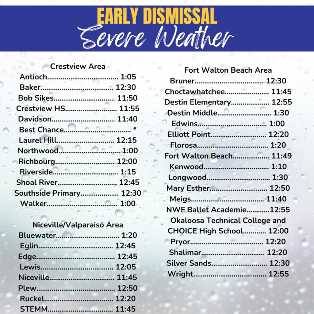
UPDATE: Okaloosa Schools will now dismiss TWO hours earlier than their regular release times today, April 10. The latest update shows that the storm conditions have adjusted with the weather now arriving in Okaloosa at 3pm.
After further communication with Okaloosa County Director of Public Safety, Patrick Maddox, this modification is to ensure our students and employees have plenty of time to arrive home safely.
As a reminder, all after-school activities, including tutoring, athletics, and daycare, are canceled. The revised dismissal times are listed in the graphic below.
— Original Story below —
The Okaloosa County School District has announced an early release for Wednesday, April 10, 2024, following a briefing with County Emergency Management Officials regarding a storm system moving into the area.
- Schools will dismiss students one hour earlier than their normal dismissal times, and all after-school programs and extracurricular activities, including practices, games, and events, have been canceled.
According to Okaloosa Public Safety Director Patrick Maddox, the county remains at an Enhanced Risk level, with a Moderate Risk just west of Florida. All modes of severe weather are possible, including strong tornadoes of EF2 or better.
“This system is, for lack of a better term, ‘messy,'” Maddox said. “It is not forecast to move in a single, strong squall line and be done with – there will likely be complexes or clusters of storms with a squall line or two forming as storms coalesce.”
The best estimate for the timing of impacts to the area is a window from 4 PM to midnight. Rainfall in the 2-4″ range is likely, with isolated pockets of 6-8″ possible in areas where thunderstorms train.
- Flash flooding and minor riverine flooding is possible, with the Shoal River forecast to reach minor flood stage by Friday at 7 AM, though no structures are currently threatened.
Non-thunderstorm wind gusts of 40 MPH are likely, particularly between 4pm and midnight, but the strongest storms could pack 80 MPH winds if they develop. Winds should begin to die down after midnight, according to Maddox. There is also a potential for hail up to quarter-size in stronger storms, but tornadoes and strong winds remain the main threats. Surf build-up of 7-9 feet is possible, beginning to abate Thursday during the day.
Normal school operations will resume on Thursday, April 11.