7PM Update:
Although there was another very slight shift in track to the East (Baldwin County landfall projected instead of Dauphin Island), no major changes to our expected impacts at this time.
The tornado watch for Okaloosa County has been extended through 6AM Wednesday as expected. The weather will continue deteriorating further overnight and sustained minimal tropical storm force winds can be expected along the immediate coast with gusts of 45-55mph moving inland trough Wednesday afternoon/early evening.
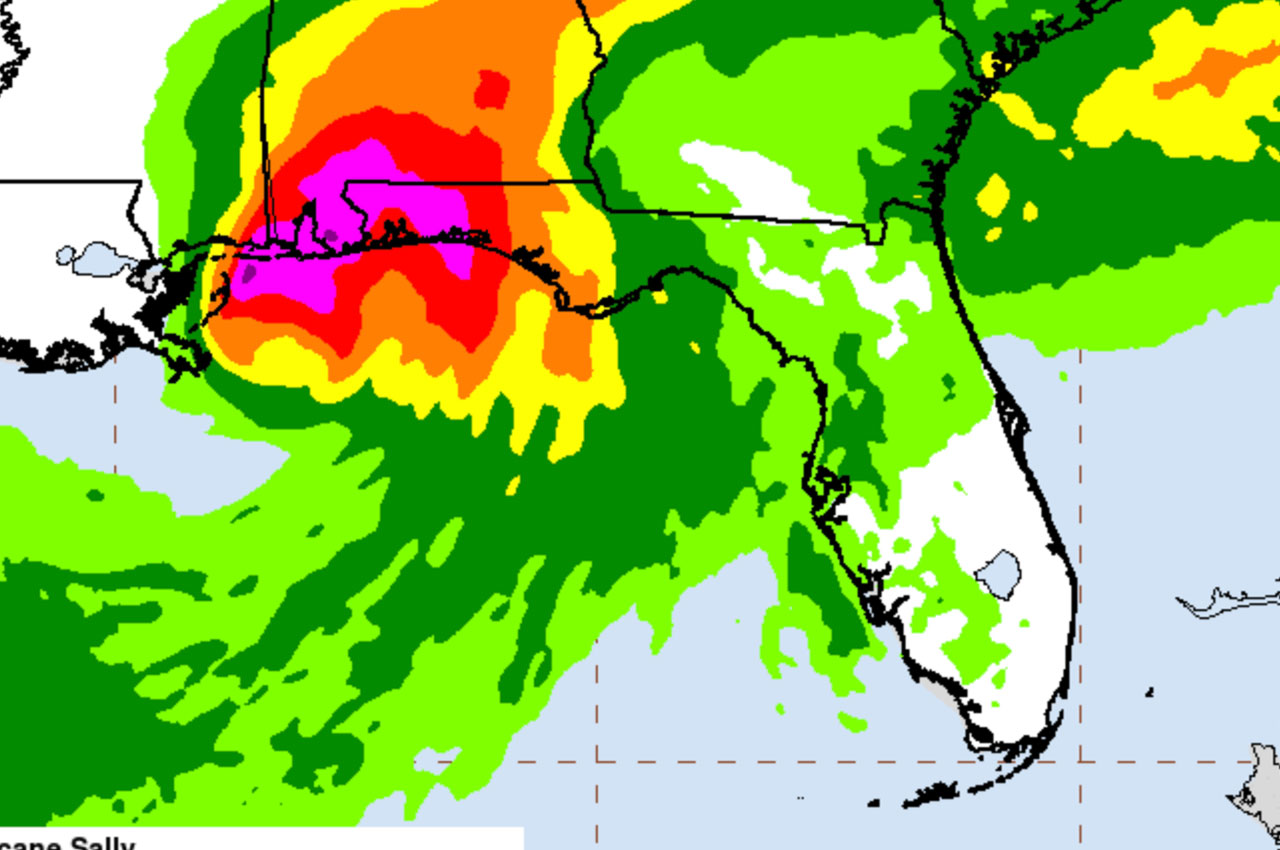
Rainfall values of 15-20 inches, with higher values in areas of training thunderstorms, are still projected throughout the county. Up to this point we have received about 6 inches of rain near the coast and about 4 inches of rain inland, according to Okaloosa Public Safety. Areas with persistent bands may have some higher values.
Original post below:
The track for Hurricane Sally has shifted a bit east again and landfall is now projected to be near Dauphin Island, Alabama around 7am on Wednesday morning.
Maximum sustained winds were still at 85mph and surface temperatures indicate that upwelling of cooler water from the shallow basin near the coast is prohibiting any significant intensification, according to Okaloosa County Public Safety.
This intensity is projected to remain at landfall and quickly weakening to a Tropical Storm afterward, per OCEM.
“The eastward shift bumped up our storm surge to 3-5 feet from 2-4 feet, which still did not put any structures at risk,” said Patrick Maddox, Okaloosa County Public Safety. “However, rainfall values across the area are raised a bit with 8-15 inches likely, pockets of 20” possible and 30” in areas of Northwest Florida which see training thunderstorms set up in static locations.
Weather will deteriorate this afternoon and evening with sustained tropical storm force winds in the 40-45mph range possible along the immediate coastal areas, with gusts into the 50mph range.
“This means that some bridges could be closed if that projection verifies,” said Maddox. “That’s the best prediction we can give on arrival of sustained Tropical Storm force winds at this point. A tornado watch is in place for our area through 6PM, but I expect that will be extended at least through the overnight hours. We should see tropical storm conditions abate late Wednesday afternoon, early evening, just in time to dig into the flood threat.”
All 3 rivers (Blackwater, Yellow and Shoal) are forecast to reach major flood stage and could see “historic flooding” if the largest amounts of anticipated rainfall are produced. Okaloosa County is preparing messaging for residents in those affected areas and will have shelter operations announced shortly.
Yesterday, the Governor’s Executive Order 20-224 for Emergency Management only included Escambia and Santa Rosa counties. The Order has been amended in EO 20-225 to include Okaloosa & Walton (along with others).